Wednesday, April 30, 2014
Monday, April 28, 2014
PLATES TECTONICS - STUDY GUIDE QUESTIONS & PLATES QUIZ
Add this video to your review sheet.
PLATE TECTONICS - VIDEO
Write the 10 questions & answers on notebook paper.
2. What do plates float on?
3. What type of rock are oceanic plates made of?
4. What type of rock are continental plates made of?
5. What is the name of the are where the crust goes back down into the Earth?
6. What is the process of new crust formation called?
7. When two continental plates collide, what types of mountains are formed?
8. What is the name of the supercontinent that existed about 200 million through 100 million years ago?
9. Who first stated the theory of continental drift?
10. Name a fossil that was found on different continents and was used to support the theory of continental drift.
 To complete the quiz - circle the correct answer. (get hand out)
TITLE: PLATES QUIZ #1
DUE: Friday, 5/13
PLATE TECTONICS - VIDEO
Write the 10 questions & answers on notebook paper.
- Use notes as needed
- Ask for handout to help with questions
- Title page: PLATE TECTONICS
- Watch the video & do the INTERACTIVE before answering questions
- PLATE TECTONICS- video #3
- PLATES INTERACTIVE - interactive #4 (click on heavy black line)
- DUE: Friday, 5/13
2. What do plates float on?
3. What type of rock are oceanic plates made of?
4. What type of rock are continental plates made of?
5. What is the name of the are where the crust goes back down into the Earth?
6. What is the process of new crust formation called?
7. When two continental plates collide, what types of mountains are formed?
8. What is the name of the supercontinent that existed about 200 million through 100 million years ago?
9. Who first stated the theory of continental drift?
10. Name a fossil that was found on different continents and was used to support the theory of continental drift.
To complete the quiz - circle the correct answer. (get hand out)TITLE: PLATES QUIZ #1
DUE: Friday, 5/13
Sunday, April 27, 2014
LIQUEFACTION FROM AN EARTHQUAKE
LIQUEFACTION
Liquefaction
is the process of loose soil acting like a liquid during an earthquake.
Most
of the time, buildings and homes are built upon solid bedrock. However,
building also happens on what seems like solid ground. But underneath a
solid layer of compact sediment, there is lurking a loose layer of sandy soil
or soil that has been saturated with water. During the shaking of a
powerful earthquake, this loose soil will act like
quicksand. When liquefaction occurs, the homes and buildings atop
this soil can sink or fall over when their foundations loosen or break
apart. The surface of the ground will become very uneven and unstable.
Crevices and gaps open up. Roads and sidewalks break into pieces and
become hazardous.

These
are not the only effects of liquefaction. Loose, sandy soil, or the water
saturated soil underneath the compact layer of sediment can make its way up
to the surface. The columns of rising sandy soil are called sand
dikes. When the sand emerges on the surface it is called a sand
boil. The results of this liquefaction phenomenon are often seen after
high magnitude earthquakes. Street pavement will break apart, and
sand boils can be seen on roadways and other areas. Sewer channels
underneath streets can rise up during liquefaction. As a result, the
manhole cover you see everyday on your way to school could be several inches to
a couple of feet higher than the surface of the road. This is a common
side effect of liquefaction. Other underground structures can break also;
important things like gas and water lines.


SOIL LIQUEFACTION EFFECTS
Click on the INTERACTIVE MAP to view current earthquakes & volcanoes

EARTHQUAKES
Earthquakes are the breaking and cracking of the rocks inside the continental plates. The breaks happen after stress has built up in the surrounding area. There are usually very few or no quakes when the plates move slowly. When there is a fast movement of the plate, there is a snap (like breaking a cracker).
BASIC EARTHQUAKE FACTS #1 (study jams)
Earthquakes occur when vast plates, or rocks, within the Earth suddenly break or shift under stress, sending shock waves rippling.·
Sudden movement along the fault causes the ground to shake.·
Most earthquakes occur along fractures in the Earth's crust called faults. ·
Intraplate quakes occur far from plate edges and happen when stress builds up and the Earth's crust is stretched or squeezed together until it rips.·
There are several different types of faults. Each can be a few inches or many hundreds of miles long. They can be horizontal, vertical, or at an angle.
Earthquake waves are measured on sensitive instruments called seismographs.·
The Richter scale assigns quakes a number based on the power of its seismic waves.·
Thousands of quakes occur every day around the globe, most of them too weak to be felt.·
Every year about 10,000 people, on average, die as a result of earthquakes.
Where Do Earthquakes Happen?
Earthquakes occur all the time all over the world, both along plate edges and along faults.

Most earthquakes happen within the ‘Ring of
Fire’ around the Pacific Ocean. Alaska experiences a 7.0 earthquake at least
once a year. California gets about 10,000 quakes a year, but most are unnoticed
except by the seismograph machines.
It is thought that
there are as many as 500,000 earthquakes every year, although only 100,000 can
be felt at all and only about 100 of those actually cause any damage.
All
around the world people are using their better understanding of earthquakes to
design safer buildings and transport systems so, although we can’t do anything
to stop the Earth shaking, we can minimize the damage caused.
Along Plate Edges
Most earthquakes occur along the edge of the oceanic and continental plates. The earth's crust (the outer layer of the planet) is made up of several pieces, called plates. The plates under the oceans are called oceanic plates and the rest are continental plates. The plates are moved around by the motion of a deeper part of the earth (the mantle) that lies underneath the crust. These plates are always bumping into each other, pulling away from each other, or past each other. The plates usually move at about the same speed that your fingernails grow. Earthquakes usually occur where two plates are running into each other or sliding past each other.
Earthquakes can also occur far from the edges of plates, along faults. Faults are cracks in the earth where sections of a plate (or two plates) are moving in different directions. Faults are caused by all that bumping and sliding the plates do. They are more common near the edges of the plates.
Why Do Earthquakes Happen?
Earthquakes are usually caused when rock underground suddenly breaks along a fault. This sudden release of energy causes the seismic waves that make the ground shake. When two blocks of rock or two plates are rubbing against each other, they stick a little. They don't just slide smoothly; the rocks catch on each other. The rocks are still pushing against each other, but not moving. After a while, the rocks break because of all the pressure that's built up. When the rocks break, the earthquake occurs. During the earthquake and afterward, the plates or blocks of rock start moving, and they continue to move until they get stuck again. The spot underground where the rock breaks is called the focus of the earthquake. The place right above the focus (on top of the ground) is called the epicenter of the earthquake.
Earthquake-like seismic waves can also be caused by explosions underground. These explosions may be set off to break rock while making tunnels for roads, railroads, subways, or mines. These explosions, however, don't cause very strong seismic waves. You may not even feel them. Sometimes seismic waves occur when the roof or walls of a mine collapse. These can sometimes be felt by people near the mine. The largest underground explosions, from tests of nuclear warheads (bombs), can create seismic waves very much like large earthquakes. This fact has been exploited as a means to enforce the global nuclear test ban, because no nuclear warhead can be detonated on earth without producing such seismic waves.
More than buildings collapse when an earthquake hits. The land itself is totally changed. You can see scars across the landscape. Those scars appear when one block of land has moved compared to another. Roads often change their placement. They either become uneven or just crack. Streams can also change course. Sometimes rocks can fall and block the stream. Other times, the land is even lowered in certain areas. When it's lower, it's easier for the water to flow in the new direction.
Changes also happen on larger scales. Fault valleys and troughs can be created. These areas have large amounts of fracturing (the fracture zone is large). After the land has opened up, weather begins to act on the area and erosion follows. Slowly, new valleys are created.
Waves Across The Land
You might think, "If it only happens in one place, why can you feel them hundreds of miles away?" The crack happens where the quake starts. Ripples then move out in waves across the plate. Those waves are called seismic waves. Those waves shake everyone up within a specific area.
 When scientists analyze an earthquake they look at several parts. They find out where the focus is. The focus is the exact point where the earthquake started. It is usually many miles/kilometers below the surface of the Earth. Scientists also look to see where the epicenter was. The epicenter is the point on the surface directly above the focus. When you think about the epicenter, try to remember there is actually a crack in the crust many kilometers below.


Primary Waves (P Waves)


Surface Waves
Several types, travel along the earth's surface or on layer boundaries in the earth. The slowest waves but the ones that do the damage in large earthquakes.
 •A
type of seismic wave that moves the ground up and down or side to side
•A
type of seismic wave that moves the ground up and down or side to side

How do scientists calculate how far a location is from the epicenter of an earthquake?
Scientists calculate the difference between arrival times of the P waves and S waves

MODIFIED MERCALLI SCALE INTERACTIVE #1 - click on the graphic


 Built For Quakes
After an earthquake, you can turn on the television and see all sorts of footage showing buildings that didn't quite survive. Buildings are built for up and down forces. If you jump on your floor a bunch of times your house will stay up. Earthquakes have forces that move side to side. Houses aren't built for that direction of energy. When the Earth moves side to side, the house can't wobble and it snaps. The walls collapse and roof falls in. Really tall skyscrapers are well designed for earthquakes. They are built to withstand strong winds. When strong winds happen, they can move side to side and sway if needed.

EARTHQUAKE - INTERACTIVE #2
You might think, "If it only happens in one place, why can you feel them hundreds of miles away?" The crack happens where the quake starts. Ripples then move out in waves across the plate. Those waves are called seismic waves. Those waves shake everyone up within a specific area.
When scientists analyze an earthquake they look at several parts. They find out where the focus is. The focus is the exact point where the earthquake started. It is usually many miles/kilometers below the surface of the Earth. Scientists also look to see where the epicenter was. The epicenter is the point on the surface directly above the focus. When you think about the epicenter, try to remember there is actually a crack in the crust many kilometers below. Elastic Rebound Theory
 | Here we have a landscape with a road, a fence, and a line of trees crossing a fault. As the crust moves, the rocks adjacent to the fault are deformed out of shape (in reality the deformation is spread across many kilometers - if it were this obvious, earthquake prediction would be easy). Eventually the rocks are so stretched out of shape that they cannot bear the stress any longer. The fault slips, and the stage is set for the next cycle of strain buildup and release. |
Epicenter and Focus
TYPE OF EARTHQUAKE WAVESPrimary Waves (P Waves)
•A
type of seismic wave that compresses and expands the ground
•The
first wave to arrive at an earthquake
Secondary
Waves (S Waves)
How do scientists calculate how far a location is from the epicenter of an earthquake?
Scientists calculate the difference between arrival times of the P waves and S waves
•The further away an earthquake is, the
greater the time between the arrival of the P waves and the S waves
How are Earthquakes Measured?
Richter
Scale
MODIFIED MERCALLI SCALE INTERACTIVE #1 - click on the graphic
EARTHQUAKE WAVES
Identify the P & S waves, Focus
Seismic Waves in the Earth
After an earthquake, you can turn on the television and see all sorts of footage showing buildings that didn't quite survive. Buildings are built for up and down forces. If you jump on your floor a bunch of times your house will stay up. Earthquakes have forces that move side to side. Houses aren't built for that direction of energy. When the Earth moves side to side, the house can't wobble and it snaps. The walls collapse and roof falls in. Really tall skyscrapers are well designed for earthquakes. They are built to withstand strong winds. When strong winds happen, they can move side to side and sway if needed.
EARTHQUAKE - INTERACTIVE #2
- complete the module to learn more about Earthquakes
- complete the Introduction & Simulation
| SAVAGE EARTH Animated Graphics: click on highlighted words & draw in your notes. Normal Fault Blind Thrust Fault Strike-Slip-Fault Dip-Slip Fault Mid-Ocean Ridge Subduction Primary Wave Secondary Wave Surface Wave Tsunami Spread |
WORDS TO KNOW:
focus
epicenter
amplification
divergent boundary
elastic rebound
foreshocks
liquefaction
normal fault
strike-slip fault
thrust fault
thrust fault
fault
focus
landslide
mantle
P wave
ocean spreading ridge
Richter scale
ring of fire
S wave
seismic wave
strike slip
subduction
transform fault
focus
landslide
mantle
P wave
ocean spreading ridge
Richter scale
ring of fire
S wave
seismic wave
strike slip
subduction
transform fault
Use the Earthquake glossary for terms & definitions
- some of terms may be explained in the notes, check the words in glossary
PLATE TECTONICS
PLATE TECTONICS IN ACTION
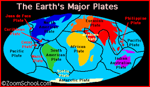
The basic idea behind plate tectonics is that there are eight major plates on the surface of the Earth. There are also bunches of minor plates. The plates are like the skin of the planet. They constantly move around the planet.
As new crust is created in a particular location on Earth, it forms what resembles giant plates. One side of the plate is where new crust is being created, while the other side is where older crust is being destroyed.
 Located
deep beneath the waves on the ocean floor almost exactly halfway between the
continents are raised areas known as ridges. These ridges are similar to
under-water mountain ranges. At other locations we find extremely deep
trenches, some reaching many thousands of feet in depth.
Located
deep beneath the waves on the ocean floor almost exactly halfway between the
continents are raised areas known as ridges. These ridges are similar to
under-water mountain ranges. At other locations we find extremely deep
trenches, some reaching many thousands of feet in depth.
 As
new crust is created, older crust submerges back into the mantle, being melted
once again. It is believed that the deep ocean trenches are locations where
crust is being lowered back into the Earth’s core.
As
new crust is created, older crust submerges back into the mantle, being melted
once again. It is believed that the deep ocean trenches are locations where
crust is being lowered back into the Earth’s core.

UPPER MANTLE
- Lithosphere (Sial and Sima)
- Asthenosphere (Molten Rock River)
- Mesosphere
LOWER MANTLE
OUTER CORE (Liquid Iron and Nickel)
INNER CORE (Solid Iron Compounds)
The top layer of the Earth's surface is called the crust (it lies on top of the plates). Oceanic crust (the thin crust under the oceans) is thinner and denser than continental crust.
Crust is constantly being created and destroyed; oceanic crust is more active than continental crust.
The Earth's Crust is like the skin of an apple. Notice how thin the crust of the Earth is in comparison to the other layers. The seven continents and ocean plates basically float across the mantle which is composed of much hotter and denser material.
*******************************.
PLATE TECTONICS - LAUNCH INTERACTIVE #2
Scientists also looked at the fossils (long-dead animal bones and plants) on the different continents. They found that fossils on Australia were similar to the ones in Southern Asia. They think the same plants once lived on the continents, but when they split apart, new plants developed. When they were digging, they also looked at the types of rocks. The West Coast of Africa has very similar rock formations to those on the East Coast of South America. They are too similar to be a coincidence.
PLATE & EARTHQUAKE INTERACTIVE #3
WORDS TO KNOW:
The basic idea behind plate tectonics is that there are eight major plates on the surface of the Earth. There are also bunches of minor plates. The plates are like the skin of the planet. They constantly move around the planet.
- When we say constantly moving, we're talking centimeters each year. You couldn't sit down and watch it happen. Or can you? You could watch it happen if you watched an earthquake.
As new crust is created in a particular location on Earth, it forms what resembles giant plates. One side of the plate is where new crust is being created, while the other side is where older crust is being destroyed.
Using
modern equipment, scientists known as oceanographers have been able to measure
and map out the ocean floor. What these scientists have discovered has helped
explain how it is that continents are able to move around on the Earth’s crust.
 Located
deep beneath the waves on the ocean floor almost exactly halfway between the
continents are raised areas known as ridges. These ridges are similar to
under-water mountain ranges. At other locations we find extremely deep
trenches, some reaching many thousands of feet in depth.
Located
deep beneath the waves on the ocean floor almost exactly halfway between the
continents are raised areas known as ridges. These ridges are similar to
under-water mountain ranges. At other locations we find extremely deep
trenches, some reaching many thousands of feet in depth.
The
amount of time that it takes for crust to be created and later destroyed is
approximately 100 million years. Thus, most crust has a lifetime of around 100
million years.

Because
continents do not fall back into the Earth’s mantle, they survive much longer.
Many parts of the continents we see today are almost as old as the Earth
itself.
Geologists
refer to this process as plate tectonics. As we study plate tectonics, a
picture emerges of very old continents riding on top of much younger and ever
moving plates. These plates move extremely slowly, at a rate of only about 10
cm per year.
PLATE TECTONICS
| Type of Crust | Average Thickness | Average Age | Major Component |
|---|---|---|---|
| Continental Crust | 20-80 kilometers | 3 billion years | Granite |
| Oceanic Crust | 10 kilometers | Generally 70 to 100 million years old | Basalt |
The theory of plate tectonics (meaning "plate structure") was developed in the 1960's. This theory explains the movement of the Earth's plates (which has since been documented scientifically) and also explains the cause of earthquakes, volcanoes, oceanic trenches, mountain range formation, and many other geologic phenomenon.
The plates are moving at a speed that has been estimated at 1 to 10 cm per year. Most of the Earth's seismic activity (volcanoes and earthquakes) occurs at the plate boundaries as they interact.
UPPER MANTLE
- Lithosphere (Sial and Sima)
- Asthenosphere (Molten Rock River)
- Mesosphere
LOWER MANTLE
OUTER CORE (Liquid Iron and Nickel)
INNER CORE (Solid Iron Compounds)
The top layer of the Earth's surface is called the crust (it lies on top of the plates). Oceanic crust (the thin crust under the oceans) is thinner and denser than continental crust.
Crust is constantly being created and destroyed; oceanic crust is more active than continental crust.
The CRUST
- It is very thin in comparison to the other three layers. The crust is only about 3-5 miles (8 kilometers) thick under the oceans(oceanic crust) and about 25 miles (32 kilometers) thick under the continents (continental crust).
- The crust of the Earth is broken into many pieces called plates. The plates "float" on the soft, plastic mantle which is located below the crust.
- These plates usually move along smoothly but sometimes they stick and build up pressure. The pressure builds and the rock bends until it snaps. When this occurs an Earthquake is the result!
Under the crust is the rocky mantle, which is composed of silicon, oxygen, magnesium, iron, aluminum, and calcium.


- Think of the molten rock in the
- The upper mantle is rigid and is part of the lithosphere - These plates make up the top layer of the Earth
- Directly under that layer is the asthenosphere.(together with the crust). The lower mantle flows slowly, at a rate of a few centimeters per year. The asthenosphere is a part of the upper mantle that exhibits plastic properties. It is located below the lithosphere (the crust and upper mantle), between about 100 and 250 kilometers deep.
- It's a flowing area of molten rock. There is constant heat and radiation given off from the center of the Earth. That energy is what constantly heats the rocks and melts them. The tectonic plates are floating on top of the molten rock and moving around the planet. Think of it as ice floating at the top of your soda. When the continents and plates move it's called continental drift.
- asthenosphere, not as rock, but as a liquid. It has currents and it flows just like any other liquid. When the floating plates spread apart, it's called a spreading center.
- When they are moving together, it's called a subduction zone.
- When they are forced together, it is called a zone of convergence. One of the plates usually moves under the other in a zone of convergence. As the plate moves down into the asthenosphere it begins to melt. The place where they meet has a crack or a trench. Some of the deepest parts of the oceans are these trenches. .
TYPES OF PLATE MOVEMENT:
Divergence, Convergence, and Lateral Slipping
At the boundaries of the plates, various deformations occur as the plates interact; they separate from one another (seafloor spreading), collide (forming mountain ranges), slip past one another (subduction zones, in which plates undergo destruction and remelting), and slip laterally.


*******************************.
PLATE TECTONICS - LAUNCH INTERACTIVE #2
- complete the module
- click on the following topics in the box on the left side of the module "DEEPER DISCOVERY",
- PLATE TECTONICS > INTERACTIVE
- BREAK UP OF PANGAEA
- PLATE BOUNDARIES
- PLATE MOVEMENTS
- PLATE TECTONICS QUIZ #2 - add score to study guide notebook paper page.
Scientific Evidence
How do we back up these ideas? Scientists have traveled all over the Earth and found evidence that supports the ideas of plate tectonics. First, they looked at the continents. Ever notice how Africa and South America look like they could fit together? Scientists did. They cut up a map, moved the continents close together, and came up with a huge landmass called Pangaea (one super-continent).Scientists also looked at the fossils (long-dead animal bones and plants) on the different continents. They found that fossils on Australia were similar to the ones in Southern Asia. They think the same plants once lived on the continents, but when they split apart, new plants developed. When they were digging, they also looked at the types of rocks. The West Coast of Africa has very similar rock formations to those on the East Coast of South America. They are too similar to be a coincidence.
PLATE & EARTHQUAKE INTERACTIVE #3
WORDS TO KNOW:
- oceanographers
- ridges
- lithosphere
- asthenosphere
- continental crust
- oceanic crust
- transform plate boundary
- plate tectonic
- seafloor spreading
- lateral slipping plate
- convergent plate
- subduction zones
- zone of divergence
- lateral slipping plate movement
- crust
PANGAEA

BREAK-UP OF PANGEA #1
Pangaea
– Whole Land
Looking at a globe reveals coincidences that are difficult to ignore. The Eastern coast of South America seams to fit perfectly, almost like a puzzle, into the Western coast of Africa. At the same time, North America can be rotated slightly, and made to fit comfortably next to Europe, and Asia.
These
clues have lead geologists and other scientists to examine the relationships of
other clues. Ancient fossil records show that the same plants and animals lived
along the Eastern coast of South America, as did along the Western coast of
Africa, as did other plants and animals along the coasts of North America and
Europe.

Complete the Module - PLATE TECTONICS #2
QUESTIONS -
- write question & answer neatly on notebook paper - PANGEA QUESTIONS
- What is Pangaea?
- What caused Pangaea to break up?
- pangaea
- geologist
Monday, April 14, 2014
WIND - SCAVENGER HUNT

WIND SCAVENGER HUNT
- Use the websites to answer the following questions.
- DUE: Thursday, April 24
·
3 important factors affect the direction that wind blows?
THE
CORIOLIS EFFECT
·
What is the coriolis effect?
WIND
FRICTION
·
What things interfere with wind, changing its direction
& speed – give examples
·
Whre is the effect of friction important?
·
Wind speed is primarily affected by? Explain
·
Which direction do winds in Northern Hemisphere move?
·
Which direction do winds in Southern Hemisphere move?
·
What are easterlies winds?
WESTERLIES
·
What are westerlies wind?
·
What is the jet stream?
·
What are polar easterlies?
SEA
& LAND BREEZES http://www.kidsgeo.com/geography-for-kids/0098-sea-land-breezes.php
·
How do sea & land breezes work? Do day & nite differ? (DRAW)
MOUNTAIN
& VALLEY BREEZES http://www.kidsgeo.com/geography-for-kids/0099-mountain-valley-breezes.php
What
are mountain & valley breezes? Do
day & nite differ? (DRAW)
WIND – HISTORY
http://kids.mtpe.hq.nasa.gov/archive/nino/global.htmlAnswer the following questions:
·
What winds would Columbus have used to travel from Spain
to the Caribbean?
·
Which winds would he have needed to return to Europe?
·
Would winds have favored European explorers seeking to
travel east around the tip of Africa?
·
Wind is caused by?
·
What scale describes & classifies the different wind
speeds is the?
·
Wind direction is measured by a?
·
Wind speed is measured with a ?
·
What are the narrow bands of strong winds called
which move around the world between about six and twelve miles high?
·
High & low pressure try to reach?
ANSWER QUIZ QUESTIONS
http://goo.gl/0O90Fq
DRAW & LABEL – Windward & Leeward winds
|
|
Subscribe to:
Posts (Atom)